Online Demonstration Events
In February, the ScaleAgData Project hosted 2 online demonstration events to showcase the achievements of its first project iteration. The event featured presentations from 5 RIL's focusing on
- Privacy-Preserving Federated Learning for Soil Data
- Usage of Weather Forecast Data to facilitate Dairy Production Planning
- Water status assessment
- Crop monitoring
- Yield Monitoring
The event brought together a diverse group of participants, including external stakeholders, promoting active engagement and meaningful exchange of ideas.
Stakeholders participated in interactive sessions, providing valuable feedback on the demonstrators' usefulness, usability and added value. Discussions also addressed key challenges, such as data accessibility, model transparency, and regional scalability. Suggestions for further development will be incorporated into the next iteration of the project to enhance system reliability and stakeholder engagement.
Soil Lab: Privacy-Preserving Federated Learning for Soil Data
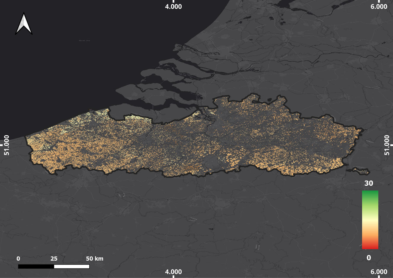
The Soil Lab implemented a privacy-preserving Federated Learning approach, enabling machine learning models to be trained on sensitive soil data while addressing privacy concerns and promoting collaboration among scientists. This method was applied to Soil Organic Carbon (SOC) modeling in Flanders (Belgium) and the Region of Central Macedonia (Greece).
By integrating Copernicus Earth Observation (EO), the Flower AI framework, and cloud computing, the technology produced detailed SOC maps while mitigating data-sharing challenges among stakeholders. This approach allows researchers to utilize diverse datasets while maintaining confidentiality, resulting in more robust and generalizable soil science models.
Consequently, it enhances the accuracy and reliability of soil predictions whether as point estimates or maps empowering growers and agronomists to make informed decisions for better field management.
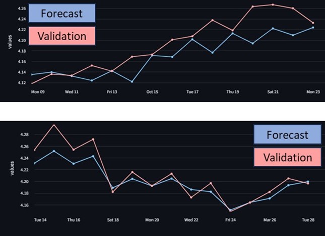
Dairy Lab: Forecasting Milk Quality for Improved Production Planning
The Dairy Lab demonstrated a predictive modeling tool that integrated meteorological data, farm level datasets, and in-situ measurements to forecast milk quality. Deployed in Northern Germany, the demonstrator aims to enhance dairy cooperatives' production planning by providing more precise insights into milk composition.
Stakeholders provided feedback on the need for real-time data integration, improved forecasting accuracy, and expanded regional scalability to maximize the tool's impact on dairy supply chain efficiency.

Water Lab: Enhancing Irrigation Decision-Making with IoT and EO Data
The Water Lab showcased field water status assessment techniques using IoT sensors and Earth Observation (EO) data. Demonstrations in Latvia and Israel focused on comparing direct soil moisture measurements with evapotranspiration-based modeling approaches. The results indicate that while IoT sensor data provides highly accurate soil moisture readings, EO data enables broader-scale assessments that could support irrigation decision-making for regions lacking sensor coverage.
Stakeholders raised concerns about spatial resolution challenges, sensor variability, and the need for region-specific calibration to improve accuracy.
Crop Lab: Advanced Crop Monitoring and Early Pest Detection
The Crop Lab presented three innovative solutions:
- Policy Monitoring Tool: A dashboard designed to assist policymakers in making data-driven decisions by aggregating and analyzing IoT and farm log data from multiple agricultural regions.
- Decision Support System for Crop Management: A web-based tool for farmers and agronomists, integrating in-situ weather data, soil conditions, and satellite-based crop monitoring to optimize wheat production.
- Early Pest Detection System: A scalable algorithm that estimates pest occurrence probabilities using meteorological data, satellite imagery, and field observations. This tool aims to improve pest monitoring efficiency and support proactive crop protection strategies.
These tools aim to improve sustainability tracking, optimize crop management, and enhance decision-making for farmers and policymakers.
Stakeholders highlighted the importance of usability, seamless integration with existing farm management systems, and further testing under diverse climatic conditions.
Yield Lab: Digital Twin & enhanced yield maps
In a separate online Demonstration Event, The Yield Lab introduced its innovative products and services to a diverse group of potential users and stakeholders, including farmers, agricultural service providers, researchers and public authority representatives.
They demonstrated how yield maps from potato harvesters can be enhanced by applying a tare weight correction and explained how an EO-based model, trained with harvester data, can generate yield estimates and variability maps for potatoes.
Additionally, they introduced a Digital Twin that estimates potential nitrogen uptake and yield for winter wheat fields.
The discussion that followed brought highly positive feedback on the usefulness and usability of the proposed services, along with valuable recommendations for further improvements.
Demonstration Events RIL Grassland in Spain & Italy
During the second week of February, demonstration events showcasing the work of the Grassland RIL (IFAPA and EURAC) were held in Spain and Italy.
During these demonstration events, teams from IFAPA and EURAC gathered forces to present results, along with innovative product and service proposals for Mediterranean and Alpine grasslands.
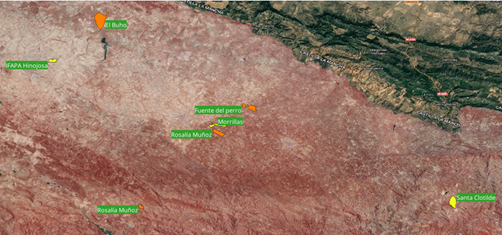
In Spain, the event focused on Mediterranean grassland productivity under uncertain climate conditions, providing quantitative information about productivity and potential stocking rates at field scale under favorable, regular, and drought conditions.
At the COVAP cooperative facilities, IFAPA presented the tools currently in development. Several examples of results obtained from specific farms associated with the cooperative were showcased. This allowed participants, including technical staff from the cooperative and researchers from the University of Córdoba, to offer feedback on the tool's utility, preferred spatial scale, usefulness, and suggestions for enhancing future services. A second demonstration event at the same location involved the owners of the analyzed farms, allowing for further evaluation.
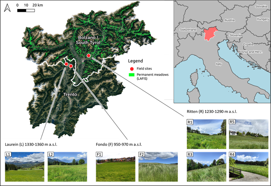
In Italy, the workshop focused on the optimization of a system to monitor the impact of drought events on the productivity of mountain grasslands in the province of Bolzano. The workshop took place at the seat of the consortium of farmers Condifesa Bolzano.
EURAC presented the ongoing work in ScaleAgData including
- the collection of extensive ground measurements for the validation of satellite-based products
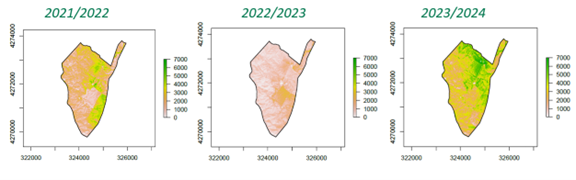
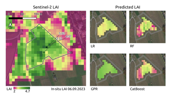
- the development of machine learning-based data fusion algorithms to improve the timeseries of leaf area index as proxy for yield, using multi-sensor data from optical and SAR sensors.
We collected useful feedback regarding the possible integration of the results of ScaleAgData in a parametric insurance scheme, prototyped by EURAC in a former project.
Researchers and practitioners in agricultural risk management reflected on challenges and opportunities in this emerging sector.